The roof of Africa
Kilimanjaro, the name itself is a mystery wreathed in clouds. It might mean Mountain of Light, Mountain of Greatness or Mountain of Caravans. Or it might not. The local people, the Wachagga, don’t even have a name for the whole massive, only Kipoo (now known as Kibo) for the familiar snowy peak that stands imperious, overseer of the continent, the summit of Africa and mostly named after “The roof of Africa” being the highest point in Africa.
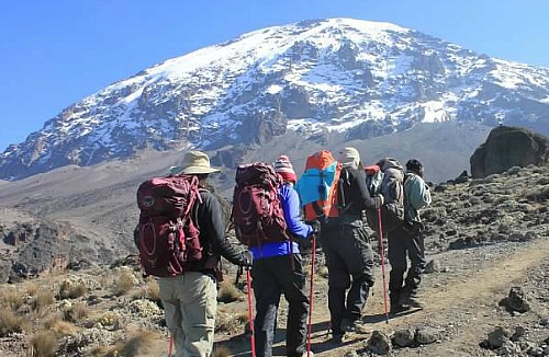
Kilimanjaro, by any name, is a metaphor for the compelling beauty of East Africa. When you see it, you understand why. Not only is this the highest peak on the African continent; it is also the tallest free-standing mountain in the world, rising in breathtaking isolation from the surrounding coastal scrubland – elevation around 900 metres – to an imperious 5,895 metres (19,336 feet).
Kilimanjaro is one of the world’s most accessible high summits, a beacon for visitors from around the world. Most climbers reach the crater rim with little more than a walking stick, proper clothing and determination. And those who reach Uhuru Point, the actual summit, or Gillman’s Point on the lip of the crater, will have earned their climbing certificates.
And their memories.
But there is so much more to Kili than her summit. The ascent of the slopes is a virtual climatic world tour, from the tropics to the Arctic. Even before you cross the national park boundary (at the 2,700m contour), the cultivated foot slopes give way to lush Montaigne forest, inhabited by elusive elephant, leopard, buffalo, the endangered Abbot’s duiker, and other small antelope and primates. Higher still lies the moorland zone, where a cover of giant heather is studded with otherworldly giant lobelias.
Above 4,000m, a surreal alpine desert supports little life other than a few hardy mosses and lichen. Then, finally, the last vestigial vegetation gives way to a winter wonderland of ice and snow – and the magnificent beauty of the roof of the continent.
About Kilimanjaro National Park
Size: 1668 sq km 641 sq miles).
Location: Northern Tanzania, near the town of Moshi.
Getting there
128 km (80 miles) from Arusha. About one hour’s drive from Kilimanjaro airport.
What to do
Six usual trekking routes to the summit and other more-demanding mountaineering routes. Day or overnight hikes on the Shira plateau. Nature trails on the lower reaches.
Trout fishing. Visit the beautiful Chala crater lake on the mountain’s southeastern slopes.
When to go
Clearest and warmest conditions from December to February, but also dry (and colder) from July-September.
Accommodation
Huts and campsites on the mountain. Several hotels and campsites outside the park in the village of Marangu and town of Moshi.
NOTE 1:
Climb slowly to increase your acclimatisation time and maximise your chances of reaching the summit. To avoid altitude sickness, allow a minimum of five nights, preferably even more for the climb. Take your time and enjoy the beauty of the mountain.
NOTE 2:
New rates for Porters and Guides (June ’08)
Porters – USD 10 per day
Cooks – USD 15 per day
Guides – USD 20 per day
Mountain Expeditions
Derived from the chagga words “Klima kya Ruwo” or “Klima cha Ruwa” meaning God’s mountain ,Kilimanjaro is a giant stratovolcano reaching an elevation of 19,335.6 ft. (5,895 m) and the only free standing volcanic mountaing in the tropic.
Also known as Oldoinyo Oibor meanin white mountain or Oldonyo sidai meaning the shining mountain due to its glitering snowy cape, Kilimanjaro ranks highest point of Africa also refered to as the roof of Africa and second highest mountain in the world after the Europe’s Everest.
Kibo is Kilimanjaro’s highest and youngest cone while Shira in the west and Mawenzi in the east are older cones and make up Kilimanjaro. Kibo has not been active in recent times, but steam and sulfur are still emitted. The top of Kibo’s summit holds a 1 1/2 mile (2 1/4 Km) wide crater.
THE SUMMIT & THE ROUTES
MARANGU ROUTE
Route highlights (at every camp/hut)
- Comfortable sleeping huts (Bed and Matress)
- Mineral water, Soda, Beer and a Chocolate.
- Radio contact with the Park headquarters
- Photographic scenery
Review:
Also known as the ‘Coca Cola Route’ Marangu route is the main and by far the most popular tourist route and some recommend it as the easiest route to ‘Uhuru’ Peak (the summit). With a high success rate! With the 5 day climb option, makes it the least expensive route to climb.
MACHAME ROUTE
Route highlights
- Tented accommodation only (Sleeping bag and a hiking mattress required)
- Photographic scenery
- Longer and steeper trekking
Review:
Machame is probably the most scenic and most beautiful route to the summit. The scenic traverse of this route offers some stunning views! The 6-day route is however physically more challenging than the Marangu route. Nevertheless, it allows the climber to see the whole southern face of Kibo. ‘No huts’ – means less comfortable tented accommodation!
RONGAI ROUTE
Route highlights
- Tented accommodation only (Sleeping bag and mattress required)
- Photographic Scenery
- Trekking
Route review:
This is the only route that ascends from the northern slopes of the mountain. It is very similar in nature to the Marangu route, but it involves camping. The addition of a sixth day offers a unique opportunity to visit Mawenzi tarn and the northern amphitheatre of Mawenzi.
UMBWE ROUTE
Route Highlights:
- Tented accommodation only (Sleeping bag and Hiking mattress required
- Photographic scenery
- Shorter but harder trekking
- Cave camp experience
Route review:
This route is one of the shorter but also one of the more difficult routes to reach Uhuru peak however, quite spectacular and takes a total of 6days to climb. Umbwe is known for its caves. The first night you actually sleep at the Umbwe Cave Camp with two more caves that can be visited en route the following day. Also sometimes used as a descending route.